Another gorgeous fall-like weekend, and another hike. This time I took my son “Jiffy Pop” with me for a bonding and trail work/ridgerunner hike and my friends from our AMC chapter “Thumbs Up” and “Chilly Cheeks” came along.
The three of us hadn’t hiked together all year as a group, and my son hadn’t done an overnight with me in almost 5 years. I leant him my old pack, my trail runners, sleeping pad, puffy jacket and camp shoes to fill in the missing gear. He loved all of it and I am going to get him some trail runners like mine for school.
We met a Connecticut Forest and Parks maintainer and his son working on their trails that connect to the A.T. on Ten Mile Hill, and cleared a blowdown, bear boxes, and two fire rings at the campsite, one right under the no fires sign. Wow, that’s always frustrating. It feels like a direct insult to us maintainers by really disrespectful campers and I wish there was honestly a way to fine them if caught, not that that will do much to discourage these types.
We did meet some nice hikers as well, and enjoyed a starry night and lots of spiders out on the Ned Anderson bridge. I saw Jim the Blue Heron, and we saw some frogs, crayfish, and enjoyed s’mores and of course, Jiffy Pop!
I checked the privies and filled the duff buckets as well, and gave a Leave No Trace speech to some kids coming into the campsite with beer and other items, and had to ask another group of teens coming in playing loud music shining bright lights in the camper tents at 230 am to turn off the music and move on. The problems here continue, and it seems the town and/ or state don’t really want to bother doing much more than having US put up the signs and barriers which keep getting pulled down, and the occasional visit once in a while by a state trooper. Way more resources (or method of closing off the area securely) will be required to contain this problem now that we no longer have our volunteer group doing it. We continue to see abuse of the area and the trash piles and rule breakers coming out in force to disrespect this beautiful area and the people that work hard to keep it that way. Shame on all of you.
Nonetheless, we did what we came to do, and had a nice time doing it. So, mission accomplished. That wraps up my summer volunteer season, though I will certainly be out doing work over the fall and winter when needed.
Watch the video here. Photos below.
Miles day 1: 3.5
Miles day 2: 1.5
— Linus

Linus, Thumbs up and Jiffy pop getting ready to hit the trail

Jiffy Pop at the trailhead

Linus, Thumbs up and Chilly Cheeks on the trail

Linus and Jiffy Pop on the trail

Linus and Jiffy Pop on Ten Mile Hill

Jiffy Pop on Ten Mile Hill

Linus and Jiffy Pop cutting a blowdown on Ten Mile Hill

Thumbs up and Chilly cheeks at the Housatonic Overlook

Jiffy pop writing in the shelter register

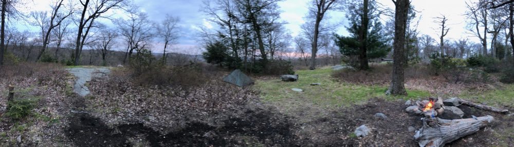
One of two prohibited fire rings I cleared

A prohibited fire ring right in front of the no fires sign. Sometimes I really wonder what the heck is wrong with people

Linus clearing a prohibited fire ring

Thumbs up and Chilly cheeks

Jiffy Pop and his favorite Mountain house

Jiffy Pop on the stove!

Spider friends

Crayfish!

Jiffy Pop at the river

Large blowdown, will have the sawyers clear it

Thumbs up and Jiffy Pop after the hike