
Scrambling up Lion’s Head
After nearly a year of studying and planning this section to death on the map, quide book, and internet and trying to piece together any memories of hiking its peaks as a boy scout, it was time to head there together.
Section 1 currently describes the route from rt 44 in Salisbury to the misplaced state line marker .6 miles in from the actual state line crossing at Sages Ravine, Massachusetts. When I was a scout, this may still have been the section route, but the section start and endpoints were different, and my BSA Appalachian Trail patch in 1984 labeled it as section VII, aka 7, for those who don’t read roman numerals. I also don’t recall if we did the whole section.

Looking north at Bear from Lion’s Head
While there was a re-route a few years later west of river and the old route becoming the Mohawk trail, it crossed back over in Falls Village to continue its original route so I’m going to assume this was still the path back then. I remember climbing either Bear or Lion’s Head, or both with the scouts, but that’s as clear as the memory gets.

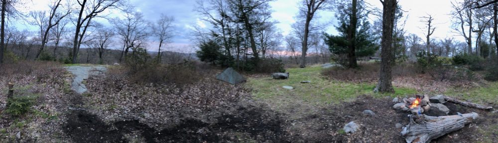
View from Riga Shelter
Working on NY sections 2 and 3 earlier this spring gave us a nice warmup for this bigger hike, while allowing us to not repeat any sections. As a couple, we had not been above 1,600 ft on any hike, overnight or otherwise. So in our heads it was quite a challenge ahead of us. But it turns out we underestimated ourselves. Now without a doubt, going from the road (700 ft) and up over Lion’s head (1,750 ft) and Bear Mtn (2,316 ft) and back down to Sages Ravine (1,600 ft) in one day would have been hard work. And we broke this up by going over Lion’s Head and spent the first night at the Riga shelter and campsites (1650 ft) with its stunning views. For this we have no regrets. But really, the next day we expected to be far more difficult than it was. Day 1 we were a bit slower-going but day 2 we already had our hiker legs kickin’ into gear.

At the top of Bear
For fear of rain on the day we were to summit and descend Bear Mtn (enhanced by a few hikers we passed and spoke to – gee, thanks!), we got a move on early. The north face of the mountain IS steep – no lie. In the rain, it would be a veritable waterfall. But despite the challenges, we summited, snacked, and descended like the best of mountain goats to Sages Ravine in 3 hours and 15 minutes. Surely, we could have gone on to tackle Race Mountain and stay at the Race Brook Falls campground. But we left our second car at Undermountain trail – so this would mean either thumbing it back, or making our 3.5 mile hike out to a greasy satisfying brunch into an 8-miler, and one that also potentially skirted a wet and slick downhill re-trace of the exposed rock ledges on Mt. Race. And the rain eventually DID come, and in droves, Friday night. So we were better off with a long, more relaxing stay at Sages Ravine.

My “Rudy” shot atop Bear
Still, we felt like champions for our speedy climb over Bear (see my “Rudy” shot), and are planning to tackle Race and Everett to Jug End in longer days next time — maybe more along 7-8 mile days than these 3-5, since we’re obviously getting the hang of this thing. While we’ve done a ten-miler, it wasn’t over two 2,000+ peaks with a 900 ft descent in between and on either side.

Steep north face of Bear
We had covered the first part of the section from rt 44 to 41 in Salisbury when we completed our last overnight section hike of CT. And I took an extra mile out-and-back loop from the campsite at Sages Ravine to the misplaced state line marker to officially bag the end of the section and satisfy my OCD, even though we will come through here again on the next one. I’m glad I did, as I got to see over 10 beautiful waterfalls and plenty of watering holes along the gorgeous ravine.

Cascade in Sages Ravine
We finished the hike with a gluttonous meal at Toymakers cafe in Falls Village, a reputably very hiker-friendly establishment. This was proven so by the cook/owner giving us a ride back to our car after a very cold rainy hike into there last fall because the bartender at the Falls Village Inn made it quite obvious he didn’t want us staying there for the night. Clearly to this individual, hikers are all unemployed, dirty and rowdy. In contrast, Toymakers also lets hikers camp in their backyard – please patronize them.
When we stopped by the Inn yesterday for the second time on a hike to get our A.T. passport stamped, the door was locked tight, there was no doorbell, and no one responded to my knocking even though I saw several people walking around in back. I don’t know why the Inn is a location for an A.T. passport stamp and not Toymakers.

The ‘Official’ end of CT
Its is not a very friendly place at all in my opinion, unless you’re dressed up nicely when you arrive and have reserved your two-hundred-and-fifty-a-night room well in advance and got your own key already when you checked in. Luckily the post office in town was more than happy to stamp my A.T. passport.
But anyway, this hike had it all – there were views for days, thru-hikers, a powerful thunderstorm to lull us to sleep, some great wildlife, and tunnels of mountain laurel. But I’ll let Fielden Stream tell you about that in part two.
— Linus

I was thrilled to read your account and visualize that section of trail! The peaks are beautiful and the Ravine is stunning. It was cold the day we hiked through there, but I thought how nice a swim on a hot day would refresh!
LikeLiked by 1 person
Glad you are following – we are having a blast as usual and it was a pleasure to meet you all! Your comment about Alabama and Nuclear lake cracked me up!
LikeLike
Looks like a wonderful backpacking experience…thank you for sharing! We are looking to hike the 51 mile Connecticut section of the AT this coming summer. I couldn’t tell from your entry if you did that same mileage. If you did, how long did it take you? We will be flying out from the West and are pretty avid hikers…just trying to get a rough estimate of how many days we will need. Thanks!
LikeLike
We’ve done all of CT now, this trip was the final section for us to finish the state. Though because of work and parenting schedules we do our backpacking on weekends in sections throughout the season, so we did CT over 5 sections through most of last season and the beginning of this one, and then started working on New York. I just didn’t start the blog until a thru-hiker I met convinced me to and we’d already done most of CT.
I’m not sure what kind of mileage and elevation gains you are used to on your hikes. Obviously the elevation isn’t as high in CT as out west but you’d be surprised how many ups and downs there are! I think anyone with good hiking experience could do it in as little as 3 days but as much as 5 if you’re taking your time and enjoying it. There are no campfires on the trail in CT so some thru-hikers prefer to blow through it in 3 days for that reason, or because they think it’s boring. But its a beautiful section of trail – you even hit 2,300 ft on our highest mountain peak, Bear.
Also I am now a volunteer trail patroller (same thing as a ridge runner but on a volunteer vs hired seasonal basis) for the CT Appalachian trail so if you run into me out there next season say hi, I’ll give you a map and tell you where the water is flowing! My real name is Adam. If you’d like to know which campsites were our favorites I’d say you can’t miss Ten Mile River, Mt Algo, Limestone Spring, and Riga. Have a great hike, enjoy Connecticut. It really is underrated.
LikeLike
That’s awesome Adam. Thanks so much for the information! When I lived back East I did the MD portion of the trail and fell in love with its diversity. That was way too many years ago and I have finally gotten life in order well enough to fly out to tackle another state 🙂 In the meantime we have done plenty of hiking out this way…to include a Mt St Helens adventure this past summer. We are definitely up for the AT challenge again but it has been a long time since I strapped on the back pack so I also have to be realistic with day hikes and overnight timing.
Hope to see you out trail patrolling…thanks for volunteering your time to the upkeep of such an amazing trail!
LikeLike
You bet! Sages Ravine is also a top-notch campsite we enjoyed on our last night, though technically it’s in Massachussets the CT section officially ends at the sign a half mile further. Our conversation with the ridgerunner there is what inspired me to get into volunteering. If you stay there and aren’t heading north into mass from there on the trail, Paradise lane to undermountain trail is a great way out without resummiting Bear and you can leave a car at the undermountain lot without issue. Hope to see ya!
LikeLike
Pingback: Massachusetts Appalachian Trail Adventure (Sections 9&10) | Happy On The Trails